Project History
It began in 2012 with an idea: Why not rethink the under-utilized space beneath a hydro corridor and repurpose the turf grass into a thriving meadow?
This would allow residents to connect with nature and contribute to the city’s eco-system. And so the Scarborough Centre Butterfly Trail (SCBT) was born.
The SCBT stretches from Thomson Memorial Park near McCowan Road and Lawrence Avenue East for 3.25 kilometres to Scarborough Golf Club Road.
Prior to 2011, this 40-hectare section of The Meadoway was mowed up to eight times a year, and lacked both habitat and biodiversity. Today, the SCBT site contains a healthy native meadow community supporting a variety of butterflies, pollinators, birds, and wildflower species.
With success comes the desire to do more. The visionaries behind the SCBT project wondered aloud if the idea could be extended. Thanks to the generous support of the Weston Family Foundation, the answer was yes.
THE MEADOWAY OVERVIEW
Ultimately, The Meadoway will feature a 16-kilometre multi-use trail for walking, cycling and other non-motorized uses, with potential for new and enhanced public spaces and gathering areas within and adjacent to the hydro corridor.
Currently, a total of 40 hectares of native meadow habitat has been restored within The Meadoway, and approximately 10 kilometres of multi-use trails have been constructed.
The objective now is to extend the existing trail network and meadow restoration program the full 16-kilometre length of The Meadoway.
Integrating The Meadoway with neighborhoods, parks, public access points, and other trail systems will promote community connectivity and augment the GTA’s bikeways network.
Restoration of the existing corridor with meadow habitat will contribute to the city’s urban greenspace and improve ecological diversity.
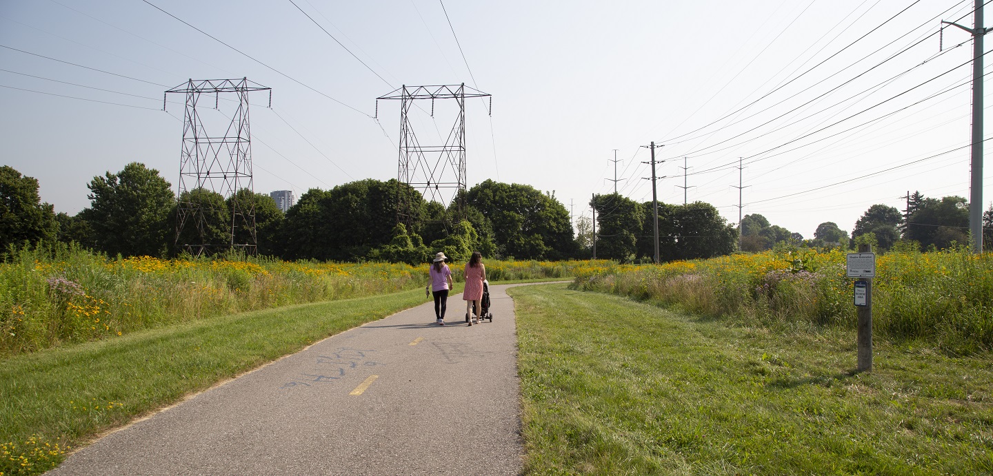
THE MEADOWAY PROJECT PRINCIPLES
The following principles will guide the transformation
of the hydro corridor into The Meadoway:
CONNECTIONS |
NATURAL ENVIRONMENT AND EDUCATION |
RECREATION |
TRANSPORTATION |
COMMUNITY AND PUBLIC REALM |
BLUEPRINT FOR REVITALIZATION |
THE MEADOWAY PUBLIC CONSULTATION
Public consultation is one of the main components in a Class EA process. It provides an opportunity for the public to engage and provide their insight on the project. Public consultation for The Meadoway Class EA was held in the form of Public Information Centres (PICs).
TRCA has now completed all three PICs for The Meadoway Class EA.
Public Information Centre #1
for The Meadoway Class EA
View the materials presented at the first PIC.
The first Public Information Centre (PIC) for The Meadoway Class EA was held on Wednesday, April 24, 2019 from 6:15 to 9:00 p.m. at Centennial College Event Centre, Winter/Fall and Vista Rooms (8th floor).
The purpose of the PIC was to introduce and seek feedback on The Meadoway Class EA and preliminary visualization toolkit.
Information presented for The Meadoway Class EA included:
- Guiding principles
- EA objectives
- Opportunity statement
- Existing conditions
- Preliminary alternative trail alignments
- Proposed evaluation criteria
The meeting also included a visioning workshop for the preliminary visualization toolkit – a set of conceptual tools that will help animate the look and feel of The Meadoway and demonstrate what is possible for the future of the hydro corridor.
The format of the PIC included an open house and workshop session with display panels and an interactive project map, followed by formal presentations and a question and answer period. A handout and comment form were also provided to encourage attendees to provide their input.
Materials Presented at PIC #1
2. CLASS EA PANELS
You can download a PDF copy of the Class EA panels HERE or view the panels using the document reader below. Select Read Now for a full-screen view; select the arrow to the right to advance to the next page.
3. PRELIMINARY VISUALIZATION TOOLKIT PANELS
You can download a PDF copy of the Preliminary Visualizations Toolkit Panels HERE or view the panels using the document reader below. Select Read Now for a full-screen view; select the arrow to the right to advance to the next page.
4. PRELIMINARY VISUALIZATION TOOLKIT MAP
You can download a PDF copy of the Preliminary Visualization Toolkit Map HERE or view the map using the document reader below. Select Read Now for a full-screen view; select the arrow to the right to advance to the next page.
Public Information Centre #2
for The Meadoway Class EA
View the materials presented at the second PIC.
The second Public Information Centre (PIC) for The Meadoway Class EA was held on Wednesday, June 26, 2019 from 4:30 to 7:30 p.m. at Thomson Memorial Park.
The purpose of the PIC was to provide an update and seek feedback on Phase 2 of The Meadoway Class EA, and on the visualization toolkit.
The focus of the meeting was on:
- Alternative trail alignments
- Preliminary evaluation of the alternative trail alignments
- Proposed preferred trail alignments
The meeting also included an interactive map for the visualization toolkit, and information on meadow restoration and education opportunities throughout The Meadoway.
The format of the PIC included an open house, display panels and guided walks.
Comments were encouraged during one-on-one conversations between staff and the public, and through an interactive project map.
Materials Presented at PIC #2
1. CLASS EA PANELS
You can download a PDF copy of the Class EA panels HERE or view the panels using the document reader below. Select Read Now for a full-screen view; select the arrow to the right to advance to the next page.
2. PROPOSED PREFERRED MULTI-USE TRAIL ALIGNMENT
You can download a PDF copy of the Proposed Preferred Multi-Use Trail Alignment HERE or click on the image below to view a full-sized version.
3. VISUALIZATION TOOLKIT MAP
You can download a PDF copy of the Visualization Toolkit Map HERE or view the map using the document reader below. Select Read Now for a full-screen view; select the arrow to the right to advance to the next page.
4. VISUALIZATION TOOLKIT PANELS
You can download a PDF copy of the Visualization Toolkit Panels HERE or view the panels using the document reader below. Select Read Now for a full-screen view; select the arrow to the right to advance to the next page.
Public Information Centre #3
for The Meadoway Class EA
View the materials presented at the third PIC.
The third and final Public Information Centre (PIC) for The Meadoway Class EA was held on Wednesday, October 23, 2019 from 6:00 to 9:00 p.m. at the Latvian Canadian Cultural Centre.


The purpose of the PIC was to provide an update and seek feedback on Phase 3 of The Meadoway Class EA, and to share with the public the completed visualization toolkit.
Information presented for The Meadoway Class EA included:
- Evaluation of design concepts for the preferred trail alignments
- Proposed preferred design concepts
- Mitigation measures
In addition, the meeting included components of the visualization toolkit, including conceptual renderings, animations, interactive map, and 3-D models. Information on meadow restoration and education opportunities throughout The Meadoway were also presented.
The format of the PIC included an open house with display panels and visual components, followed by formal presentations and a question and answer period.
Comments were encouraged during one-on-one conversations between staff and the public, through an interactive project map, and during the question and answer period. A handout and comment form were also provided to encourage attendees to provide the project team with feedback on Phase 3 of The Meadoway Class EA.
Materials Presented at PIC #3
1. PRESENTATIONS
Multi-use Trail Class Environmental Assessment
Visualization Toolkit Update
2. CLASS EA PANELS
You can download a PDF copy of the Class EA panels HERE or view the panels using the document reader below. Select Read Now for a full-screen view; select the arrow to the right to advance to the next page.
3. PROPOSED PREFERRED MULTI-USE TRAIL ALIGNMENT
You can download a PDF copy of the Proposed Preferred Multi-Use Trail Alignment HERE or click on the image below to view a full-sized version.
4. VISUALIZATION TOOLKIT MAP
You can download a PDF copy of the Visualization Toolkit Map HERE or view the map using the document reader below. Select Read Now for a full-screen view; select the arrow to the right to advance to the next page.
5. VISUALIZATION TOOLKIT PANELS
You can download a PDF copy of the Visualization Toolkit Panels HERE or view the map using the document reader below. Select Read Now for a full-screen view; select the arrow to the right to advance to the next page.