
General Questions About The Meadoway
Q: WHAT IS THE MEADOWAY?
A: The Meadoway is the name given to a new initiative in Scarborough to revitalize the 500 acres and 16 linear kilometers of hydro corridor between the Don River Ravine and Rouge National Urban Park.
Q: WHERE EXACTLY IS THE MEADOWAY IN TORONTO?
A: The Meadoway is in the east end of the city and will run across Scarborough, within the hydro corridor between the new East Don Trail in the Don River ravine to the main trails in Rouge National Urban Park while also connecting to the Highland Creek ravine system in Morningside Park. A map of The Meadoway can be found HERE.
Q: WHO OWNS THE LAND THAT THE MEADOWAY IS ON?
A: The Province of Ontario owns the land; it is managed by Hydro One Networks Inc. (HONI) for power transmission.
Q: ISN'T THERE ALREADY A PATH ALONG THE CORRIDOR?
A: The City of Toronto has developed the trail in sections along the hydro corridor, but it is not connected. The Meadoway will utilize these completed sections of trail and build a full connection across the 16-kilometre, 500-acre area, enabling users to travel all the way from downtown Toronto to Rouge National Urban Park.
A Class Environmental Assessment was completed to determine the preferred trail route that will make up the full 16-kilometre connection.
For more information on the preferred trail route see Questions About The Meadoway Design & Construction.
Q: WHO WILL OVERSEE THE MAINTENANCE OF THE MEADOWAY?
A: Toronto and Region Conservation Authority (TRCA) will work with City of Toronto staff to lead the maintenance of The Meadoway, including aspects that relate to the trails, meadowlands, urban agriculture sites and litter removal in these areas.
Q: WILL I BE PERMITTED TO WALK IN AND EXPLORE THE MEADOWS?
A: Meadow habitats are sensitive to disturbance and may contain a wide range of delicate plants and animals. In addition, the restored meadows will take several years to take hold and establish successful roots, which can be impacted by plant tissue damage and soil compaction associated with trampling.
Because of this sensitivity, it is recommended that people using the hydro corridor enjoy the meadow habitat from a distance and remain on the trails whenever possible.
Q: WILL THE MEADOW DRAW WILD ANIMALS SUCH AS COYOTES TO THE AREA?
A: As with any healthy functioning ecosystem, there may be a wide range of animals found in The Meadoway, including birds, frogs and mammals such as chipmunks, rabbits and even deer.
While uncommon, it is possible that larger mammals such as coyotes may be spotted in The Meadoway; however, they are generally timid and do not pose a danger to people.
You can participate in the City of Toronto’s Coyote Response Strategy by calling 416-338-PAWS (7297) or by filling out an online form at toronto.ca/animalservices if you spot a coyote.
Q: WILL OFF-LEASH DOGS BE ALLOWED IN THE AREA ONCE THE TRAIL IS CONSTRUCTED?
A: Dog owners will be required to comply with the City of Toronto’s Animals Bylaw within The Meadoway, which requires all dogs to be leashed unless within a designated off-leash dog park.
Q: WILL THE TRAIL BE ACCESSIBLE FOR PEOPLE WITH MOBILITY ISSUES?
A: TRCA and its partners have worked to ensure that the preferred trail alignment determined through the Class environmental assessment process meets the design standards of the Accessibility for Ontarians with Disabilities Act (AODA), where possible. The AODA and its standards ensure that recreational trails allow for people of all abilities to move through and enjoy the natural environment.
Q: ARE THERE HEALTH RISKS TO BEING IN THE HYDRO CORRIDOR?
A: The City of Toronto conducted a comprehensive study in 2008 that focused on the human health impacts of hydro corridors. The results of the study indicated that conducting typical recreational activities in the hydro corridor is safe.
Q: WHAT WILL HAPPEN TO THE HYDRO TOWERS?
A: The hydro towers will remain in The Meadoway, as they deliver essential power requirements for the City of Toronto. The multi-use trails, high-functioning meadow habitat, and urban agriculture opportunities will transform what was once known as an area used for energy transmission into a place that connects natural areas and redefines the connection between the built structure of a city and natural spaces.
Q: WILL THE MEADOWAY HAVE TICKS OR OTHER BITING/STINGING INSECTS?
A: As with all Toronto Parks, there is the possibility of coming across biting/stinging insects in The Meadoway.
Due to the recent effects of climate change, ticks have begun to make their way into the Greater Toronto Area (GTA) and it is possible that some may be found in The Meadoway once restored.
As with all outdoor activities in the GTA, taking precautions is important: stay on the multi-use trail; check for ticks following a hike; wear long pants tucked into socks; and carry an epi-pen if needed.
Q: WHAT IS THE TOTAL AMOUNT OF FUNDING THAT THE PROJECT REQUIRES?
A: The project was originally estimated to have a budget of $85 million, which included an ambitious pedestrian bridge over Highway 401.
We have now identified a route across Conlins Road utilizing an existing trail that is currently being upgraded by the City, and therefore the bridge over the 401 is no longer a part of the current project plan.
Estimates for the project are now approximately $38 million, a total that includes completing the 16 km of multi-use trail, installing wayfinding and signage, building bridges over Highland Creek and Ellesmere Ravine, planting and maintaining 115 hectares of meadow habitat, and running annual community engagement and education programs.
Q: WHERE ARE THE FUNDS COMING FROM?
A: The Weston Family Foundation has pledged up to $25 million in support, with an initial commitment of $10 million announced at the launch event on April 11, 2018.
The City of Toronto has to date committed $6.3 million for a total Phase 1 budget of $16.3 million.
Additional funds are still being sought to complete Phase 2 of The Meadoway between 2021 and 2024.
Q: CAN I DONATE TO HELP WITH THE IMPLEMENTATION OF THE MEADOWAY?
A: Yes! Toronto and Region Conservation Foundation works with TRCA to raise funds to help support The Meadoway. You can make a donation HERE.
Q: HOW CAN I STAY UPDATED ON THE PROGRESS OF THE MEADOWAY?
A: To learn more about the next steps for implementing The Meadoway and receive updates about upcoming community participation opportunities, you can join our mailing list.
Questions About The Meadoway Class Environmental Assessment
Q: WHAT IS AN ENVIRONMENTAL ASSESSMENT?
A: An environmental assessment is a planning and decision-making tool applied to a variety of projects in order to minimize or avoid adverse environmental effects before they occur.
An environmental assessment incorporates environmental factors into the decision-making process and ensures opportunity for meaningful public and stakeholder feedback.
Q: WHAT ARE THE BENEFITS OF AN ENVIRONMENTAL ASSESSMENT?
A: By considering environmental effects and mitigation measures early in the planning process, an environmental assessment can support better decision-making and result in many benefits, such as:
- Avoidance or minimization of adverse environmental effects
- Opportunities for public participation and Indigenous consultation
- Increased protection of human health
- Reduced project costs and delays
- Reduced risks of environmental harm or disaster
- Increased agency accountability
- Informed decisions that contribute to responsible development
Q: WHAT IS A MUNICIPAL CLASS ENVIRONMENTAL ASSESSMENT?
A: A Municipal Class Environmental Assessment, often referred to as a Class EA for short, is a standardized planning process for classes (or groups) of activities that are carried out on a routine basis and have predictable environmental effects. A Class EA process “Schedule C” was undertaken for The Meadoway.
Q: WHY WAS AN ENVIRONMENTAL ASSESSMENT UNDERTAKEN FOR THE MEADOWAY?
A: A Class EA process was undertaken for The Meadoway in order to complete the planning and design of the multi-use trail for the approximately six kilometres that remain to be constructed.
The Class EA process was a critical planning tool for the five potential pedestrian bridges that will span the various rail lines and river valleys, as well as the potential pedestrian road crossings.
Q: OUTSIDE OF THE MAIN TRAIL WITHIN THE CORRIDOR, WERE CONNECTIONS TO ADJACENT TRAIL SYSTEMS EXPLORED AS PART OF THE PROCESS?
A: Yes. Identifying the potential to expand the multi-use trail beyond the footprint of the hydro corridor was a key component of the Class EA process.
The Meadoway is planned to connect to the Pan Am Path and the new East Don Trail, two major multi-use trail connections. Other multi-use trails connections have also been identified in the study area, including the Highland Creek Trail.
Connectivity is one of the guiding principles of this project. Not only does The Meadoway intend to connect multiple trails, but also create connections with cycling routes and vehicular and rail transportation routes.
Q: WHAT OPPORTUNITIES DID THE PUBLIC HAVE TO BE INVOLVED IN THE MEADOWAY CLASS EA PROCESS?
A: Consultation and engagement were key to The Meadoway Class EA process. It provided an opportunity for individuals, groups, and Indigenous communities to contribute to the decision-making in a meaningful way.
During the course of the Class EA, three public events — called Public Information Centres (PICs) — were held for the members of the community to learn about the project and provide input at key stages of the process.
In addition, regular project updates were — and will continue to be — added to this website and sent out through our monthly newsletter (subscribe HERE).
If you have any comments or questions, please contact us at info.themeadoway@trca.ca.
Q: WHAT IS THE STATUS OF THE MEADOWAY ENVIRONMENTAL STUDY REPORT (ESR)?
A: The Environmental Study Report (ESR) for The Meadoway Multi-use Trail Class Environmental Assessment was completed and submitted to the Ministry of Environment, Conservation, and Parks (MECP) in December 2019. The Meadoway Class EA received MECP approval in January 2020.
The planning of the multi-use trail has now moved into the Phase 5 detailed design stage, where the design is refined and plans, specifications, and estimates are developed in preparation for implementation.
Questions About The Meadoway Design & Construction
1. DETAILED DESIGN
Q: WHAT HAPPENS DURING DETAILED DESIGN?
A: During detailed design, the preferred conceptual alignments identified during the Class EA are further refined, and plans, specifications, and other technical information is prepared in support of trail construction.
Q: DOES THE PROJECT HAVE TO GO THROUGH ANY REVIEWS OR PERMITS?
A: Yes. A number of permits and approvals will need to be secured prior to trail construction. Acts, regulations, and City by-laws that may need to be adhered to include but are not limited to the Migratory Birds Convention Act, Ontario Heritage Act, Conservation Authorities Act, Ravine and Natural Feature Protection By-law, and Noise Control By-law.
In areas where the proposed route is located within Hydro One property, or where it crosses public utilities, additional review and approvals will be required before implementation.
2. GENERAL DESIGN PARAMETERS
Q: WHAT IS THE GENERAL DESIGN FOR THE TRAIL?
A: New sections of The Meadoway multi-use trail will be designed to match the existing network and will follow the “primary trail” configuration as defined in the City of Toronto Multi-use Trail Guidelines (2015).
The multi-use trail will be comprised of an asphalt surface with a minimum width of 3.6 m and can be shared by people walking, in wheelchairs, pushing strollers, running, in-line skating, and cycling.
Q: WHERE WILL THE PROPOSED TRAIL BE LOCATED?
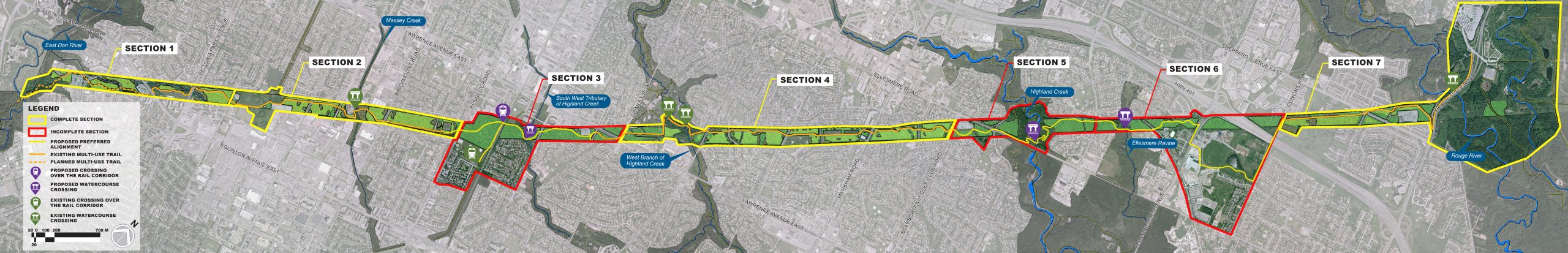
A: New sections of trail will be implemented primarily within the footprint of the hydro corridor, where existing gaps in The Meadoway multi-use trail network currently exist:
- Section 3 – Between Kennedy Road and Eglinton Avenue East
- Section 5 – Scarborough Golf Club Road to Neilson Road
- Section 6 – Neilson Road to Conlins Road
The preferred alignments were identified and evaluated through a Class EA process, with significant stakeholder and public input, and a number of factors were assessed to determine the most suitable trail location, including physical, natural, social-economic, and cultural environments.
You can view the sections of The Meadoway by downloading a PDF copy of THIS MAP, or click on the image below to view a full-sized version.
Q: WILL TRAIL AMENITIES BE PROVIDED (E.G. SIGNAGE, ETC.)?
Q: Will trail amenities be provided (e.g., signage, etc.)?
A: Some trail amenities may be located at nodal points (where the trail meets the road, other trails or parkland), and may include garbage receptacles, wayfinding and signage, as well as bicycle parking.
These amenities — including specific locations, type, and details — will be determined in the detailed design phase of the study.